06/03/2025
[Fr] Décès de Philippe Auclerc
C'est avec tristesse que nous avons appris aujourd'hui le décès de Philippe Auclerc, co-fondateur de la maison d'édition "Loire et terroirs" et rédacteur...
Published on 31 January 2013 - Updated 11 February 2013
Cet article date d'il y a plus de 12 ans
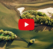
The "e-terroir" mapping web application allows users to view the thematic maps of a vineyard: terroir units, soil depth, water reserves, potential for early growth, etc. As such, vine-growers can be guided in their technical choices with a view to optimising the way vines are tended and promote the wine-making potential of a terroir.
All of the land surveys (between 1/10 000 and 1/5 000) and construction of thematic maps follow the methodology for mapping and characterising wine-growing regions developed by the Angers INRA (French National Institute for Agricultural Research) office. These maps can be used at plot level.
This application has been created by InterLoire (Interprofession des Vins de Loire) and the Cellule Terroirs Viticoles (association between InterLoire and Institut Français de la Vigne et du Vin) and produced by Vinogéo. For the time being, it concerns the Loire Valley vineyards mapped by the "Cellule Terroirs Viticoles".


![Nouvelles Renaissance(s] 2023](/var/storage/images/val-de-loire-refonte/dossier-de-parametrage/pied-de-page/nouvelles-renaissance-s-2023/517479-13-fre-FR/Nouvelles-Renaissance-s-2023_image_largeur220.png)