- Home
- Know
- A la carte
- Orléans - Blois
- The Mauves River of Beauce
The Mauves River of Beauce
Published on 13 April 2017 - Updated 16 November 2018
We’re now with Louis Marie Coyau, a Geographer.

The Mauves River of Beauce
We’re now with Louis Marie Coyau, a Geographer.
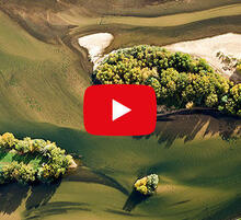
The train is following the Beauce Plateau which stretches out towards the north. As the landscape is flat, water tends to seep into its surface rather than flow over the ground and the result is surprising. It is plateau countryside, we’re on the edge of the Beauce plateau so it’s very flat, and the majority of the lie of the land only changes by around 2 or 3 metres. The main relief, as with any true plateau, is a hollow.
What’s invisible to our eyes is the fact that the plateau is made up of a stack of different layers... The first layer is formed of silt, 1 metre thick, often less, sometimes a bit more, and this silt represents the richness of Beauce. It’s this that you can see, the beautiful red-brown colour. Below this silt there is Beauce limestone, at around 25 metres thick. As limestone is soluble, the water seeping through, mainly melting snow, dissolves it, leading to areas of weakness which are filled with silt from above. Underneath we’re left with far more diverse subsoil than the surface suggests: maybe caves, maybe just simple little tunnels. Below this Beauce limestone we find the layer of clay, sand and impermeable gravel. This layer of clay supports the groundwater table and as a result water is captured here and ends up in the groundwater. This groundwater is on a slight slope towards the south/south-west so ends up emerging as springs in the region we call Mauves. This forms quite abundant springs since in Mauve de Suèvres, during the 18th century, there were four mills over 2 kilometres.
The spring is the groundwater table coming out of the earth again and the thickness of the groundwater table depends on how much we’ve pumped out or how much it has received as rainwater. So when it doesn’t receive much rain or we exploit the groundwater table too much, the level drops, at the same time the source of the River Mauve will be further downstream than when the groundwater table is very full and the level of the source becomes higher, by tens of or even several hundred metres. The train crosses this by a viaduct. It’s the only green and hilly landscape of the whole journey.
Listen
See also:
Vous n’avez pas trouvé l’information que vous cherchiez dans cette page ?
Demandez-nous
Bien reçu !
Nous vous répondrons prochainement.
L’équipe de la Mission Val de Loire.


![Nouvelles Renaissance(s] 2023](/var/storage/images/val-de-loire-refonte/dossier-de-parametrage/pied-de-page/nouvelles-renaissance-s-2023/517479-13-fre-FR/Nouvelles-Renaissance-s-2023_image_largeur220.png)